Showing posts with label earthquakes. Show all posts

Tuesday, March 9, 2010

Chile Earthquake Moved Entire City 10 Feet To The West


From Wired Science:

The magnitude 8.8 quake that struck near Maule, Chile, Feb. 27 moved the entire city of Concepcion 10 feet to the west.

Precise GPS measurements from before and after the earthquake, the fifth largest ever recorded by seismographs, show that the country’s capital, Santiago, moved 11 inches west. Even Buenos Aires, nearly 800 miles from the epicenter, shifted an inch. The image above uses red arrows to represent the relative direction and magnitude of the ground movement in the vicinity of the quake.

Read more ....

Wednesday, March 3, 2010

Earth's Earthquake Hotspots

The Seward highway in Alaska after the 1964 earthquake / USGS

From Live Science:

The powerful magnitude 8.8 earthquake that rocked Chile was strong enough to shift the planet's axis by 3 inches, and came soon after the catastrophic magnitude 7.0 quake that devastated Haiti and right after a magnitude 7.0 event hit off the coast of Japan.

Where might earthquakes hit next? Earth scientists might not be able to give us a date and time, but using history and plate tectonics as a guide they can come up with some rough estimates as to where.

Read more ....

Why Chile’s Massive Earthquake Could Have Been Much Worse

From Discover Magazine:

Less than two months after the earthquake that shook Haiti, and only hours after a quake causing small tsunamis occurred near Japan, the largest of 2010’s seeming barrage of big seismic events hit Chile. The 8.8 earthquake is the fifth largest since 1900. “We call them great earthquakes. Everybody else calls them horrible,” said USGS geophysicist Ken Hudnut. “There’s only a few in this league” [AP].

According to seismologists, the confluence of earthquakes these last couple months are probably coincidental; they’re all separated by too great a distance to be directly related. However, some say the latest quake is related to the 1960 quake in Chile that remains the largest ever recorded, a 9.5 on the Richter scale.

Read more ....

Tuesday, March 2, 2010

Chilean Quake May Have Shortened Earth Days

This view of Earth comes from NASA's Moderate Resolution Imaging Spectroradiometer aboard the Terra satellite. (Credit: NASA)

From Science Daily:

Science Daily (Mar. 2, 2010) — The Feb. 27 magnitude 8.8 earthquake in Chile may have shortened the length of each Earth day.

JPL research scientist Richard Gross computed how Earth's rotation should have changed as a result of the Feb. 27 quake. Using a complex model, he and fellow scientists came up with a preliminary calculation that the quake should have shortened the length of an Earth day by about 1.26 microseconds (a microsecond is one millionth of a second).

Read more ....

Where The Quakes In Chile Struck

This map of topography and water depth along the Chilean coast shows quake locations and magnitudes (black circles), with lighter colors indicating higher elevation on land and shallower depth in the water. The boundary where the two tectonic plates converge is marked by a red line. Also there is a trench where the Nazca Plate begins to dive beneath the South America Plate. When these plates get locked together for any time the pressure will eventually break, resulting in an earthquake like the 8.8 magnitude temblor on Feb. 27. Credit: NASA Earth Observatory.

From Live Science:

The 8.8-magnitude earthquake that devastated parts of Chile was the result of a collision between two giant slabs of Earth.

The jolt occurred along a so-called subduction zone, where one tectonic plate dives beneath another. In this case, the Nazca Plate is plowing under the South America Plate at an average rate of 3 inches (80 millimeters) a year. In addition to the Feb. 27 earthquake and others, the plate collision gives rise to the spectacular Andes Mountains.

Read more ....

Chile Quake Among Most Powerful Ever


From Discovery News:

The so-called megathrust quake that rocked the western coast of South America is the most powerful of its kind.

THE GIST:

* The 8.8-magnitude earthquake is similar to the 2004 Indian Ocean temblor that triggered devastating tsunamis.
* Called megathrusts, these quakes occur when one tectonic plate dives beneath another.
* The Chile tremor unleashed about 50 gigatons of energy.

The huge earthquake that struck off the coast of Chile belongs to an "elite class" of mega earthquakes, experts said, and is similar to the 2004 Indian Ocean temblor that triggered deadly tsunami waves.

Read more ....

A Bird's Eye View Of The Chile Earthquake's Energy Distribution

NOAA's Distributed Energy Map of the Chile Earthquake NOAA

From Popular Science:

It’s easy to think of tsunamis as phenomenon that mimic the behavior of ripples on the surface of water; you toss a stone into a pond and the resulting energy from the splash moves out away from the epicenter in a series of even, concentric circles. But this NOAA energy distribution map from the 8.8 magnitude earthquake in Chile over the weekend tells a different story.

Read more ....

Sunday, February 28, 2010

Chile Earthquake: Is Mother Nature Out of Control?


From Live Science:

Chile is on a hotspot of sorts for earthquake activity. And so the 8.8-magnitude temblor that shook the capital region overnight was not a surprise, historically speaking. Nor was it outside the realm of normal, scientists say, even though it comes on the heels of other major earthquakes.

One scientist, however, says that relative to a time period in the past, the Earth has been more active over the past 15 years or so.

Read more ....

Friday, February 26, 2010

Disaster Awaits Cities In Earthquake Zones

Istanbul has a program to secure its schools against earthquakes. Above, construction at the Atakoy Lisesi school. Johan Spanner for The New York Times

From The New York Times:

ISTANBUL — As he surveys the streets of this sprawling mega-city, Mustafa Erdik, the director of an earthquake engineering institute here, says he sometimes feels like a doctor scanning a crowded hospital ward.

It is not so much the city’s modern core, where two sleek Trump Towers and a huge airport terminal were built to withstand a major earthquake that is considered all but inevitable in the next few decades. Nor does Dr. Erdik agonize over Istanbul’s ancient monuments, whose yards-thick walls have largely withstood more than a dozen potent seismic blows over the past two millenniums.

Read more ....

Friday, February 12, 2010

Geographers Help Map Devastation in Haiti


Screenshot of MCEER's Virtual Disaster Viewer.
(Credit: MCEER, State University of New York at Buffalo)


From Science Daily:

Science Daily (Feb. 11, 2010) — In the wake of the earthquake in Haiti, University at Buffalo geography students are participating in a global effort to enhance the international response and recovery effort by helping to assess damage, using images hosted by Google Earth and the Virtual Disaster Viewer, which shares imagery of disasters from various sources.

Read more ....

Thursday, February 4, 2010

Headache Pill Could Save Earthquake Crush Victims

Rescue carries its own dangers (Image: Roberto Schmidt/Getty)

From New Scientist:

JUST one tablet of paracetamol (acetaminophen) could help save earthquake survivors who otherwise risk dying from kidney failure after rescue. Experiments in rats have shown that the drug prevents "crush syndrome", or rhabdomyolysis, in which muscle debris from crushed limbs floods the kidneys soon after the limb is freed from rubble, causing them to fail.

"When you release the pressure on muscle through rescue, debris goes to the kidney. It's like a chain reaction, and acetaminophen blocks it," says Olivier Boutaud of Vanderbilt University in Nashville, Tennessee, and head of the research team.

Read more ....

Saturday, January 30, 2010

Quakes 'Decade's Worst Disasters'

From BBC News:

Almost 60% of the people killed by natural disasters in the past decade lost their lives in earthquakes, a UN-backed report has revealed.

Storms were responsible for 22% of lives lost, while extreme temperatures caused 11% of deaths from 2000 to 2009.

In total, 3,852 disasters killed more than 780,000 people, according to a report by the Centre for Research on Epidemiology of Disasters (CRED).

Asia was the worst-affected continent, accounting for 85% of all fatalities.

Read more ....

Wednesday, January 27, 2010

Scientists Return To Haiti To Assess Possibility Of Another Major Quake

In a pre-earthquake photo, a GPS receiver and antenna sit atop a roof in Port-au-Prince, Haiti. (Credit: Purdue University/Eric Calais)

From Science Daily:

Science Daily (Jan. 27, 2010) — A team funded by the National Science Foundation (NSF) is returning to Haiti this week to investigate the cause of the January 12, magnitude 7 earthquake there.

The geologists will collect crucial data to assess whether the quake could trigger another major event to the east or west of Port-au-Prince, Haiti's capital.

Read more ....

Sunday, January 24, 2010

Mississippi Delta Earthquake: America's Haiti Waiting to Happen?

A CAMP FOR THOUSANDS - As many as 50,000 Haitians sleep in this earthquake survivor camp in the Del Mas area in Port-au-Prince, Haiti, Jan. 21, 2010. It has grown by thousands since the U.S. Army 82nd Division's 1st Squadron, 73rd Cavalry Squadron started distributing food and water there last week. DoD photo by Fred W. Baker III

From ABC News:

Scientists Predict Haiti-Magnitude Quake Along Fault Under Miss. Delta.

One of the strongest series of earthquakes ever to hit the United States happened not in Alaska or along California's San Andreas fault, but in southeast Missouri along the Mississippi River.

In 1811 and 1812, the New Madrid fault zone that zig zags through five states shook so violently that it shifted furniture in Washington, D.C., and rang church bells in Boston. The series of temblors changed the course of the Mississippi River near Memphis, and historical accounts claim the river even flowed backward briefly.

Read more ....

Saturday, January 23, 2010

Study: Large Earthquake Could Strike New York City

All known quakes, greater New York-Philadelphia area, 1677-2004, graded by magnitude (M). Peekskill, NY, near Indian Point nuclear power plant, is denoted as Pe. Credit: Sykes et al.

From Live Science:

The New York City area is at "substantially greater" risk of earthquakes than previously thought, scientists said Thursday.

Damage could range from minor to major, with a rare but potentially powerful event killing people and costing billions of dollars in damage.

A pattern of subtle but active faults is known to exist in the region, and now new faults have been found. The scientists say that among other things, the Indian Point nuclear power plants, 24 miles north of the city, sit astride the previously unidentified intersection of two active seismic zones.

Read more ....

Friday, January 22, 2010

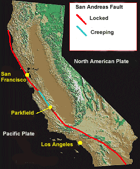
San Andreas Fault: Could Earthquake Happen Sooner Than Expected?


From Christian Science Monitor:

The frequency of a major earthquake along a key stretch of California’s San Andreas fault could be greater than thought, according to studies published Thursday in the journal Science.

The interval between major earthquakes along a key stretch of California's San Andreas fault appears to be shorter than current assessments indicate, according to two related studies published Thursday.

If these results – in the journal Science – hold up under additional scrutiny, they suggest that this section in southern California, which was responsible for the 1857 Fort Tejon quake, may be relatively close to another rupture.

Yet buried within that estimate may be some good news.

Read more
....

Tuesday, January 19, 2010

Earthquake Risk: Seismic Gap South of Istanbul Poses Extreme Danger

Geoscientists expect an earthquake along the North Anatolian Fault. (Credit: Copyright GFZ)

From Science Daily:

Science Daily (Jan. 19, 2010) — The chain of earthquakes along the North Anatolian fault shows a gap south of Istanbul. The expected earthquakes in this region represent an extreme danger for the Turkish megacity. A new computer study now shows that the tensions in this part of the fault zone could trigger several earthquakes instead of one individual large quake event.

Read more ....

Sunday, January 17, 2010

Another Indonesian Earthquake Set To Strike

The island of Sumatra, Indonesia. Darker blue indicates deeper waters (up to 5,000 m); light blue/white indicated shallow waters and sea level. Not far from the western coast of Sumatra, the Australian Plate is sliding under the Sunda plate. Marked in red is the city of Padang, which may yet see worse Earthquakes. Credit: NASA Earth Observatory

From The Cosmos:

PARIS: A huge earthquake, capable of generating a tsunami as deadly as the 2004 Indian Ocean tsunami is set to strike off the Indonesian island of Sumatra, according to seismologists.

Led by John McCloskey, a professor of the Environmental Sciences Research Institute at the University of Ulster, Northern Ireland, who predicted a 2005 Sumatran quake with uncanny accuracy, the seismologists issued the warning in a letter to the journal Nature Geoscience.

Read more ....

Caribbean At Risk Of More Large Earthquakes

More to come? (Image: KPA/Zuma/Rex Features)

From New Scientist:

Earthquake experts are warning that the devastating quake that struck Haiti on Tuesday could be the first of several in the region. They say historical records suggest that not all the energy that has built up in the faults running through the Caribbean region was released in this week's tragedy.

Their fear is that enough energy remains in the fault system to trigger another earthquake of the same scale as Tuesday's.

Read more ....

Scientists Scramble to Analyze Haiti’s Seismic Risk

(Click to Enlarge)

From Wired Science:

Since the ground shook Port-Au-Prince, Haiti, on January 12 and sent the densely populated city into chaos, scientists have been harnessing every possible tool to quickly assemble a detailed picture of a region in which scientific research had already been difficult to conduct.

The question we are trying to address right now is if there could be other faults nearby or perhaps other portions of the fault to the east or west that could go,” says Eric Calais, a geophysicist at Purdue University in West Lafayette, Ind., who has used GPS stations to monitor the area since 2003.

Read more ....